Showing posts with label Waterfalls. Show all posts

Tuesday, April 6, 2010

Sungai Tua Waterfall @ Ulu Yam [10th Feb 2010]

Barely just few days before the Chinese New Year, together with my buddy, we ventured into the deep of Ulu Yam for waterfall. It has been more than a week since our last outdoor as Mum forbids me from doing something too outdoor since Chinese New Year was just around the corner. However, with the weather soaring at a high temperature, I couldn't resist but to go against my Mum's order.

Since it was on the weekday, we left Sunway at 10am to avoid the traffic. We traveled using the MRR2 highway cutting through by LDP Expressway, passing by Kepong and Batu Caves. Then we continue traveling on the coastal way of the Ulu Yam that leads to Genting Highland passing by the famous Batu Dam. After near to half an hour on the coastal way, we finally reached the carpark.
P3 Car park
There were many car park there, being labelled with P1, P2 and P3. P3 will be the most practical as it was the nearest to the main fall that located right opposite of the road.

We chose to head down to the river for some trekking before coming back for the main fall. The park was maintained and there was a security guard collecting RM 1 per person as an entrance fee to the park.
Stairs leading down to the river

Time for some trekking!=)

While you were walking down the stairs, you could see a huge water falling to the river on the concrete reinforced slope.
Doesn't it look like some monsoon drain?

Flowing down to the stream beneath

At the end of the staircase, you could see a suspension bridge linking to the other side of the stream.
Suspension bridge
The suspension bridge was solid, in fact one of the most solid I have ever experienced.

When you were on the bridge, you could hear the serene sound of the water flowing. The view of the endless stream together with the green surroundings were an eye healer.
The stream flowing from upstream

Flowing to the seemingly endless downstream

The view was irresistibly too great for a shot=p

Bamboo Forest

Strictly no burning!

Perfect spot for a picnic

The fall connected from the upper main fall

Slippery area ahead on the boulders

Since it was crowded on the first fall, we decided to trek deeper into the forest. We were trekking against the flow of the stream with the hope of more waterfalls ahead.
Starting of the trail

The trail was not very clear and it was indeed very confusing. We were watching our steps to ensure that we did not strayed too far away. We made sure that we trekked by the side of the stream just in case we lost our way.
Malaysian should learn to respect the Mother Nature!
Seriously, please do not litter around for our future generation sake. Leave nothing but footprints!

Some wild floras

After 15 minutes of trekking, we passed by an area of stream where it was full with small rocks and boulders.
Shallow stream

We continued trekking and shortly, we passed by a small area span of bamboo trees.
Bamboo trees

Some obstacles are expected

I have been to a number of waterfalls near Klang Valley region and I have to conclude that Sungai Tua did offer a very different experience of trekking and venturing. It's greenish surroundings with bamboo trees, other tropical trees and it's terrain layout making it a very unique experience not being offered by other waterfalls.
A peaceful and serene view

Such an eye healer!

A great spot begging for some dips and picnics

Some stream crossing were needed

After another 10 minutes of trekking, we decided to stop trekking further. We could not see any hint of waterfalls but an endless long river ahead.
The spot where we chilled

Pretty strong current

Mother Nature Jacuzzi

Snacks for the Day

We chilled here, had some dips and our back massaged by the nature Jacuzzi. Hock Beng spent most of the time soaking in the cold water while I enjoyed sitting on the rock boulder healing my eyes and listening to the peaceful flow of the stream.
Great place to re-energize

The water level was just slightly above the knee level and it varies from one area to another area. The best part about the stream were that it was not rocky beneath making it suitable for swimming.
Trees shading the sun

A Golden Pool

What doing us?

Crystal clear water

After chilling for nearly 2 hours, we decided it's time to make a move for lunch.
Tree trunks were everywhere

Wild berries?

We lost our way back to the starting trail as the trail was very confusing. Luckily, with the aid of the stream, we were able to get back to the main pool after 30 minutes of trekking.
The trail leading back to the main fall

At the main fall

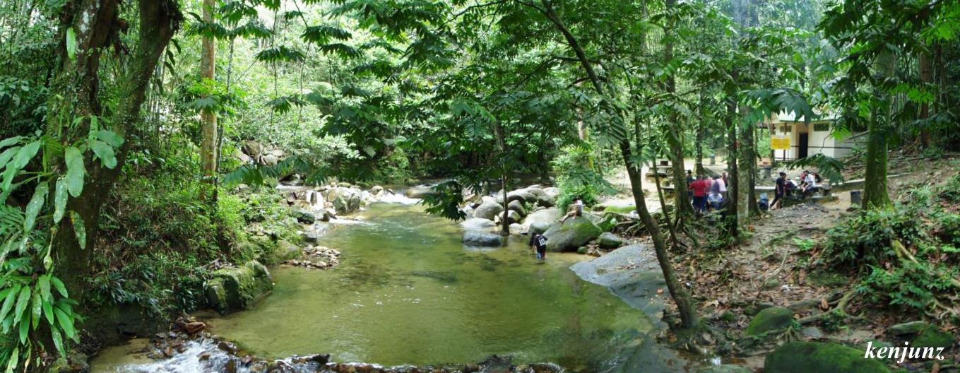
Panoramic view of the waterfall park

We crossed the road for the upper main fall which is visible from the road side.
The Ulu Yam costal way

The Upper Main Fall

There was a sizeable pool for those who want some dips at the main fall. However, it was not suitable for swimming as the water level were just at the knee level. Perhaps, it was because of the dry season and it should be deeper during the rainy season.
Strong cascades

The two adventurers of Sungai Tua for the day

The water was fairly cold and good for dips during the hot weather. For those who are more adventurous, you can opt to travel deeper into the upper stream of the river to explore the possibility of hidden treasures that lies in the deep jungle. With the shallow river and an easy access to the stream, this place is also a great spot for family outing involving children for some picnics.

Definitely, it was a very enjoyable experience and would love to be back with more people. Maybe for the next time we should have some BBQ.=)

Tuesday, February 2, 2010

Bukit Apeh Hike [10th Jan 2010]

We somehow got ourselves addicted to outdoor hiking activities. This time round, we decided to venture into Bukit Apeh, a very famous hiking hill among the Cheras residents. It was my fourth consecutive weeks of hiking activities with my steady leg, Hock Beng and the third consecutive weeks with Mei Kheng. Meanwhile, we welcomed Michael and Iris on joining us for outdoor for the very first time.

We were supposed to meet up at Cheras Leisure Mall by 7.00am but due to some miss communications, we only departed from Cheras Leisure Mall by 8am. It took us barely 10 minutes to Taman Cuepacs, where we had our breakfast before starting out the adventure.

The entrance trail was actually very near to the place we had our breakfast. Unfortunately, we went around before seeking guidance from a security guard of a residential area to the entrance trail. There were no proper car park and we just parked our car by the road side, doing the Malaysians way.
Walk to the entrance trail
We have to passed by the residential area for about 5 minutes before reaching the entrance trail. Many people were seen walking up and down of this road.

The entrance of the trail
You will see a Tenaga electricity power hub here as a landmark.

It's almost 9am, and time to hike up

An upward slope welcoming us
Just after a slight distance from the entrance trail, there was a 45 degree upward slope trail. Obviously, it does scares me a little but thankfully, it was just a short trail before it gets back to a leveled terrain.

A clear easy trail

A tub of fresh latex
Any fresher you gotta tap it yourself. And I'm wondering who will collect those latex.

After barely 15 minutes of hike, we succumbed into a diverged trail. We were confused on which trail to be taken to lead us to the summit.

Tainted signboard
Honestly, we do not have any idea of what does station 3 and station 6 means. A wild guess at that time tells us that station 6 should be the summit. Thankfully, we bumped into a group of elderly and they told us that we should followed the trail the station 6.

A little bit upward sloping

And downward sloping

And after 25 minutes elapsed from the entrance of the trail, we reached a tiny stream where we saw this little bridge. The little bridge was a like a busy road, people were seen waiting for their turns to cross it. Alternatively, if you do not have the patience, you can opt to cross the little stream if you do not mind getting your shoe soaked into some water.

The tiny little bridge

After crossing over the bridge, I saw something which very much reminds me the experience I had with Gunung Datuk.

A 70 degrees upward slope @_@

The back view of the starting point to this torturous trail

Rope or trees, just cling on to them to get some support

Some little obstacles are expected, good for the mind ya?

Time for a break, time for some toblerone

It is still upward sloping

After a torturous of 40 minutes of upward sloping, we finally made it to the check point which they called it as Station 6. This check point has two diverged trail, where one will leads you to the summit of Bukit Saga while the other one will leads you to the waterfall.

Yes, we made it to the station 6!=)

Clear signboard showing it's 28 minutes to the Saga Summit

An erected shade for people to chill

The entrance of the trail that will lead to the waterfall
We will come back here later after getting done with the summit of Saga Hill.

The clock is now showing 10am. It's time to gear up for the marching up to the Saga Hill.

The biggest tree I spotted along the trail

Sun lights through the canopy=)

This tree definitely looked amazing

There is a lot of of Atapchi tree along the trail leading us to the summit of Saga Hill. It looks like a little oil palm tree, but do not look down on them as they have sharp spikes all grown over the branches. Please stay your body and hand away from these trees.
Plentiful of them

Another easy clear trail here

It's getting nearer, go go go

Some unique ferns spotted along the trail
This fern reminds of "Jarum Emas" fern where I used to collect it with my primary schoolmates back in my days in SRK Sri Damai.

Durian tree?

Yet another clear easy trail before reaching the top=)

We reached to the summit of Saga Hill approximately after 35 minutes of hiking and walking from Station 6.

The view at the summit of Saga Hill
There were no nice panoramic view of the city nor the forest. However, there were plentiful of amenities spotted here ranging from numerous huts, camps to a little playground.

The trail map

It's us at the summit of Saga Hill. Bravo guys!=)

Board erected to show you are at the top of Saga Hill
We do not really know whether are we at the top at Saga Hill, but I guess this sign board was not erected to mislead us right? In Saga Hiking Group we trust.

Time to be a little kiddy=P

The Apek Gang with Apek Shoe and Apek Stick

Yes, it's another hill done=)

Since there were nothing much we can do, we just hang around at the summit for barely 20minutes before we headed back to Station 6.

Back to Station 6 time

It's a toilet

Some fallen trees along the trail

I was bemused by this pair of tree

After yet another 30 minutes of walk from the summit of Saga Hill, we were back to the Station 6. We had a 5 minute break before continuing our journey for the waterfall.

Really have no idea on where is Station 4 or 5

After 10 minutes of walk from Station 6
What? Still got 30 minutes? Initially, we were told by an Uncle that it will take another 30 minutes of walking from the Station 6 to reach to the waterfall. Clearly, the Uncle lied to us or was it our pace too slow?

Entering some little canopy of the tree

Marching on and we still could not hear any sound of the falls yet

A very serious signboard

Another trail with lotsa Atapchi tree welcoming

Cute trees spotted along the trail

Some unique flower
We saw this flower lying on the floor. There were plentiful of them but we do not what it was. Was it the Dandelion flower?

Time to have some taste of it

After half an hour of walking from the Station 6, we reached a trail where it was all the downward sloping of at least 60 degree. I would not say it was tough, but clearly it was challenging enough to keep my mind working over time.

Descending time people

Thankfully there were rope along the trail

Another downward sloping

We could hear the sound of water falling by this time. It gets louder as we descended further. We were excited but we did not rushed as we would want to prevent any unfortunate incident. Since it was the first outdoor activities with Michael, Iris and Esther, we reminded them to be careful and give them some little basic guidance.

The slippery boulder at the end of the trail to the waterfall

A check with the clock showed that we took 50 minutes from Station 6 to reach to this waterfall.

A mini waterfall
This waterfall might be the most mini one I've seen, but the water is pretty chilly even at the noon time. It definitely wins over the Kanching Waterfalls in term of the coldness of the water.

Yes, please do not litter around

A stream but where it leads to?

A mini little rapid

The joy of waterfall, I just love them=)

Pipe water from the falls, made easy for hand washing

What doing us?

Yay! Here we are at the Bukit Apeh Falls!

Good place to meditate

Yes, another waterfall seen=)

Chachos with my self-prepared dip
Sorry guys. I wanted to prepare some better food but I was lacking of time the day before. Promised there will be better food next time.

Fried Rice by Mei Kheng
Thanks again Mei Kheng for preparing yet another meal for us=)

The serenity that is offered by the fall

A group picture time before heading home

We slacked for more than an hour at the waterfall before we decided that it's time to head back to the entrance trail. At this point of time I knew that I couldn't make it to the movie with Mei Mei and Nai Shan at the supposedly 4pm. I'm so sorry about it=(

Ascending time

My back view while ascending

Yes, it was really that steep

It took us just 40 minutes to reach back to Station 6, clearly faster compared to the time we took to reach to the waterfall. We took another 5 minutes of break here before continuing our journey back to the entrance of the trail at Taman Cuepacs.

The box that contains First Aid Kit unit and some teapots

View of some residential house spotted when on the way down

We reached to a diverged trail after 20 minutes of walk from the Station 6. It has a signboard that told us that it is not encouraged to use the right side of the trail. I thought we should took the less encouraged trail, but luckily Michael and Esther had a good memories and were quick to correct me and lead us to the original trail where we were from.

The warning signboard

After another 30 minutes of walk, we finally reached this stall, signaling us that the entrance trail is just steps away.

The abandoned stall?

The clock was showing 3.05 pm by the we reached the entrance trail. We had some drinks by the little stall to re energize ourselves before heading for a late lunch. In the end, the adventure was not that tough, but I would not say it was easy too. It was a long walk really, with different sets of terrain and trail that will be sure to put a stern test to your physical and mental. Honestly, I felt kinda drained after that.

This is yet another outdoor activity that I enjoyed despite me having like 2 hours of sleep only the night before. We do hope that Michael, Iris and Esther will join us more frequent for the future outdoor activities=)

The members of the memorable hike
Related Posts Plugin for WordPress, Blogger...